The Flickr Ascraeusmons Image Generatr

About

This page simply reformats the Flickr public Atom feed for purposes of finding inspiration through random exploration. These images are not being copied or stored in any way by this website, nor are any links to them or any metadata about them. All images are © their owners unless otherwise specified.

This site is a busybee project and is supported by the generosity of viewers like you.

Ascreaus Mons Flank (THEMIS_IOTD_20250520a) by ASUMarsSpaceFlight

© ASUMarsSpaceFlight, all rights reserved.

Ascreaus Mons Flank (THEMIS_IOTD_20250520a)

This VIS image shows a cross section of the eastern flank of Ascraeus Mons. Ascreaus Mons is the northernmost volcano of the three large Tharsis volcanoes. In order from north to south the volcanoes are Ascreaus Mons, Pavonis Mons and Arsia Mons. All three volcanoes form a line located along a tectonic bulge caused by extensional forces in the region. Along this trend there are increased tectonic features, collapse features, and additional lava flows that arose from the flanks of the volcanoes rather than just the summit. Like the other large volcanoes in the region, Ascraeus Mons is a shield volcano. Shield volcanoes are formed by lava flows originating near or at the summit, building up layers upon layers of lava. In shield volcanoes summit calderas are typically formed where the surface collapses into the void formed by an emptied magma chamber. Ascraeus Mons is the largest of the three volcanoes with a summit of 18km (11 miles) and a width of 460 km (286 miles). For comparison Mauna Kea - the tallest volcano on Earth - is 10.2 km tall (6.3 mi) measured from the base on the sea floor.


This martian scene spans 17 x 261 kilometers (11 x 162 miles). To see where on Mars this area lies, and to download high-resolution versions of the image go to themis.asu.edu/zoom-20250520a

See the Red Planet Report at redplanet.asu.edu for updates on Mars research and exploration. For more about Mars geology, check out the Mars-ePedia: marsed.asu.edu/marsepedia

For the latest THEMIS Mars images as received by mission scientists, see themis.asu.edu/livefrommars. To learn more about the THEMIS camera and its Mars images, see themis.asu.edu

This image is in the public domain and may be republished free of charge. If used, please credit it as NASA/JPL-Caltech/Arizona State University.

Mars - Cloudy Ascraeus Mons - ESA Mars Express by Andrea Luck

Available under a Creative Commons by license

Mars - Cloudy Ascraeus Mons - ESA Mars Express

Video animation here: flic.kr/p/2r5pcg2

Download full size image: www.flickr.com/photos/192271236@N03/54527645750/sizes/o/ (see license below)

Credit: ESA/DLR/FUBerlin/AndreaLuck CC BY

Animation created processing data from: psa.esa.int/
Mission: ESA Mars Express
North is approx up
Instrument: HRSC
Orbit: 24799
Date: 2023-08-22T12:38:24.551Z
Raw Data:
HO799_0000_RE4.img
HO799_0000_GR4.img
HO799_0000_BL4.img

Credit: ESA/DLR/FUBerlin/AndreaLuck CC BY

Feel free to share, giving the appropriate credit and providing a link to the original image: creativecommons.org/licenses/by/3.0/

Video - Mars - Cloudy Ascraeus Mons - ESA Mars Express by Andrea Luck

Available under a Creative Commons by license

Video - Mars - Cloudy Ascraeus Mons - ESA Mars Express

Download full size video here: www.flickr.com/video_download.gne?id=54527403179
(See license below)
Credit: ESA/DLR/FUBerlin/AndreaLuck CC BY

Full image: flic.kr/p/2r5qrnh

Animation created processing data from: psa.esa.int/

Mission: ESA Mars Express
North is approx up
Instrument: HRSC
Orbit: 24799
Raw Data:
HO799_0000_RE4.img 2023-08-22T12:38:24.551Z
HO799_0000_ND4.img 2023-08-22T12:36:30.547Z
HO799_0000_IR4.img 2023-08-22T12:34:37.518Z
HO799_0000_S14.img 2023-08-22T12:34:15.594Z
Colours:
HO799_0000_RE4.img
HO799_0000_GR4.img
HO799_0000_BL4.img

Notes: Three HRSC map projected filters were processed with GIMP. Due to the different spectral responses of these filters, I used a script created by Simeon Schmauß (www.flickr.com/photos/semeion) to deflicker the frames (explanation: bsky.app/profile/stim3on.bsky.social/post/3lcsvbai6nc2g)

Credit: ESA/DLR/FUBerlin/AndreaLuck CC BY

Feel free to share, giving the appropriate credit and providing a link to the original media: creativecommons.org/licenses/by/3.0/

Ascraeus Mons Flank (THEMIS_IOTD_20250411a)jpg by ASUMarsSpaceFlight

© ASUMarsSpaceFlight, all rights reserved.

Ascraeus Mons Flank (THEMIS_IOTD_20250411a)jpg

This VIS image shows a cross section of the eastern flank of Ascraeus Mons. Ascreaus Mons is the northernmost volcano of the three large Tharsis volcanoes. In order from north to south the volcanoes are Ascreaus Mons, Pavonis Mons and Arsia Mons. All three volcanoes form a line located along a tectonic bulge caused by extensional forces in the region. Along this trend there are increased tectonic features, collapse features, and additional lava flows that arose from the flanks of the volcanoes rather than just the summit. Like the other large volcanoes in the region, Ascraeus Mons is a shield volcano. Shield volcanoes are formed by lava flows originating near or at the summit, building up layers upon layers of lava. In shield volcanoes summit calderas are typically formed where the surface collapses into the void formed by an emptied magma chamber. Ascraeus Mons is the largest of the three volcanoes with a summit of 18km (11 miles) and a width of 460 km (286 miles). For comparison Mauna Kea - the tallest volcano on Earth - is 10 km tall (6.2 miles).

This martian scene spans 18 x 267 kilometers (11 x 166 miles). To see where on Mars this area lies, and to download high-resolution versions of the image go to themis.asu.edu/zoom-20250411a

See the Red Planet Report at redplanet.asu.edu for updates on Mars research and exploration. For more about Mars geology, check out the Mars-ePedia: marsed.asu.edu/marsepedia

For the latest THEMIS Mars images as received by mission scientists, see themis.asu.edu/livefrommars. To learn more about the THEMIS camera and its Mars images, see themis.asu.edu

This image is in the public domain and may be republished free of charge. If used, please credit it as NASA/JPL-Caltech/Arizona State University.

Mars - Cloudy Ascraeus Mons - ESA Mars Express by Andrea Luck

Available under a Creative Commons by license

Mars - Cloudy Ascraeus Mons - ESA Mars Express

Credit: ESA/DLR/FUBerlin/AndreaLuck

Download Full size image here: www.flickr.com/photos/192271236@N03/53355719014/sizes/o/

Image created processing data from: archives.esac.esa.int/psa

Mission: ESA Mars Express
Instrument: HRSC
Orbit: 24799
Time: 2023-08-22
Product IDs:
HO799_0000_ND3 as Red Channel
HO799_0000_GR3 as Green Channel
HO799_0000_BL3 as Blue Channel

Credit: ESA/DLR/FUBerlin/AndreaLuck

Feel free to share, giving the appropriate credit and providing a link to the original image or tweet: creativecommons.org/licenses/by/3.0/

Ascraeus Mons Flank (THEMIS_IOTD_20240501a) by ASUMarsSpaceFlight

© ASUMarsSpaceFlight, all rights reserved.

Ascraeus Mons Flank (THEMIS_IOTD_20240501a)

This VIS image shows a cross section of the western flank of Ascraeus Mons. Ascreaus Mons is the northernmost volcano of the three large Tharsis volcanoes. In order from north to south the volcanoes are Ascreaus Mons, Pavonis Mons and Arsia Mons. All three volcanoes form a line located along a tectonic bulge caused by extensional forces in the region. Along this trend there are increased tectonic features, collapse features, and additional lava flows that arose from the flanks of the volcanoes rather than just the summit. Like the other large volcanoes in the region, Ascraeus Mons is a shield volcano. Shield volcanoes are formed by lava flows originating near or at the summit, building up layers upon layers of lava. In shield volcanoes summit calderas are typically formed where the surface collapses into the void formed by an emptied magma chamber. Ascraeus Mons is the largest of the three volcanoes with a summit of 18km (11 miles) and a width of 460 km (286 miles). For comparison Mauna Kea - the tallest volcano on Earth - is 10.2 km tall (6.3 mi) measured from the base on the sea floor.

This martian scene spans 18 x 267 kilometers (11 x 166 miles). To see where on Mars this area lies, and to download high-resolution versions of the image go to themis.asu.edu/zoom-20240501a

See the Red Planet Report at redplanet.asu.edu for updates on Mars research and exploration. For more about Mars geology, check out the Mars-ePedia: marsed.asu.edu/marsepedia

For the latest THEMIS Mars images as received by mission scientists, see themis.asu.edu/livefrommars. To learn more about the THEMIS camera and its Mars images, see themis.asu.edu

This image is in the public domain and may be republished free of charge. If used, please credit it as NASA/JPL-Caltech/Arizona State University.

Ascraeus Mons Flank.jpg (THEMIS_IOTD_20240426a) by ASUMarsSpaceFlight

© ASUMarsSpaceFlight, all rights reserved.

Ascraeus Mons Flank.jpg (THEMIS_IOTD_20240426a)

This VIS image shows a cross section of the southwestern flank of Ascraeus Mons. Ascreaus Mons is the northernmost volcano of the three large Tharsis volcanoes. In order from north to south the volcanoes are Ascreaus Mons, Pavonis Mons and Arsia Mons. All three volcanoes form a line located along a tectonic bulge caused by extensional forces in the region. Along this trend there are increased tectonic features, collapse features, and additional lava flows that arose from the flanks of the volcanoes rather than just the summit. These collapse features are visible at the bottom of the image.

Like the other large volcanoes in the region, Ascraeus Mons is a shield volcano. Shield volcanoes are formed by lava flows originating near or at the summit, building up layers upon layers of lava. In shield volcanoes summit calderas are typically formed where the surface collapses into the void formed by an emptied magma chamber. Ascraeus Mons is the largest of the three volcanoes with a summit of 18km (11 miles) and a width of 460 km (286 miles). For comparison Mauna Kea - the tallest volcano on Earth - is 10.2 km tall (6.3 miles, as measured from the base on the sea floor).

This martian scene spans 18 x 263 kilometers (11 x 163 miles). To see where on Mars this area lies, and to download high-resolution versions of the image go to themis.asu.edu/zoom-20240426a

See the Red Planet Report at redplanet.asu.edu for updates on Mars research and exploration. For more about Mars geology, check out the Mars-ePedia: marsed.asu.edu/marsepedia

For the latest THEMIS Mars images as received by mission scientists, see themis.asu.edu/livefrommars. To learn more about the THEMIS camera and its Mars images, see themis.asu.edu

This image is in the public domain and may be republished free of charge. If used, please credit it as NASA/JPL-Caltech/Arizona State University.

Ascraeus Mons (THEMIS_IOTD_20240416a) by ASUMarsSpaceFlight

© ASUMarsSpaceFlight, all rights reserved.

Ascraeus Mons (THEMIS_IOTD_20240416a)

This VIS image shows the upper elevations of Ascraeus Mons. Ascreaus Mons is the northernmost volcano of the three large Tharsis volcanoes. In order from north to south the volcanoes are Ascreaus Mons, Pavonis Mons and Arsia Mons. All three volcanoes form a line located along a tectonic bulge caused by extensional forces in the region. Along this trend there are increased tectonic features, collapse features, and additional lava flows that arose from the flanks of the volcanoes rather than just the summit. Like the other large volcanoes in the region, Ascraeus Mons is a shield volcano. Shield volcanoes are formed by lava flows originating near or at the summit, building up layers upon layers of lava. In shield volcanoes summit calderas are typically formed where the surface collapses into the void formed by an emptied magma chamber. Ascraeus Mons is the largest of the three volcanoes with a summit of 18km (11 miles) and a width of 460 km (286 miles). For comparison Mauna Kea - the tallest volcano on Earth - is 10 km tall (6.2 miles, measured from the base below sea level).

This martian scene spans 17 x 259 kilometers (11 x 161 miles). To see where on Mars this area lies, and to download high-resolution versions of the image go to themis.asu.edu/zoom-20240416a

See the Red Planet Report at redplanet.asu.edu for updates on Mars research and exploration. For more about Mars geology, check out the Mars-ePedia: marsed.asu.edu/marsepedia

For the latest THEMIS Mars images as received by mission scientists, see themis.asu.edu/livefrommars. To learn more about the THEMIS camera and its Mars images, see themis.asu.edu

This image is in the public domain and may be republished free of charge. If used, please credit it as NASA/JPL-Caltech/Arizona State University.

Ascraeus Mons Summit (THEMIS_IOTD_20240401a) by ASUMarsSpaceFlight

© ASUMarsSpaceFlight, all rights reserved.

Ascraeus Mons Summit (THEMIS_IOTD_20240401a)

This VIS image shows part of the summit of Ascraeus Mons. Ascraeus Mons is the northernmost and tallest of the three large aligned Tharsis volcanoes. Calderas are found at the tops of volcanoes and are the source region for magma that rises from an underground lava source to erupt at the surface. Volcanoes are formed by repeated flows from the central caldera. The final eruptions can pool within the summit caldera, leaving a flat surface as they cool. Calderas are also a location of collapse, creating rings of tectonic faults that form the caldera rim. Ascraeus Mons has several caldera features at its summit. Ascraeus Mons is 18 km (11 miles) tall, for comparison Mauna Kea - the tallest volcano on Earth - is 10 km tall (6.2 miles, measured from the base below sea level).

This martian scene spans 17 x 261 kilometers (11 x 162 miles). To see where on Mars this area lies, and to download high-resolution versions of the image go to themis.asu.edu/zoom-20240401a

See the Red Planet Report at redplanet.asu.edu for updates on Mars research and exploration. For more about Mars geology, check out the Mars-ePedia: marsed.asu.edu/marsepedia

For the latest THEMIS Mars images as received by mission scientists, see themis.asu.edu/livefrommars. To learn more about the THEMIS camera and its Mars images, see themis.asu.edu

This image is in the public domain and may be republished free of charge. If used, please credit it as NASA/JPL-Caltech/Arizona State University.

Perspective view of Mars’s Tharsis volcanoes by europeanspaceagency

© europeanspaceagency, all rights reserved.

Perspective view of Mars’s Tharsis volcanoes

This oblique perspective view shows a slice of Mars imaged to mark a milestone for ESA’s Mars Express: its 25 000th orbit around the Red Planet.

It was generated from a digital terrain model and the nadir (downward-pointing) and colour channels of Mars Express’s High Resolution Stereo Camera. The vertical scale is exaggerated by a factor of approximately three, making the volcanoes look three times higher than they are in real life.

Three of Mars’s famously colossal volcanoes are shown here: from left to right, Arsia, Pavonis and Ascraeus Mons. The mound of Mars’s largest volcano, Olympus Mons, can be spied further away at the top of the frame, while the fractured terrain of Noctis Labyrinthus, Mars’s ‘labyrinth of night’, can be seen in the foreground.

Read more

[Image description: This image shows a tan-coloured portion of Mars, with the curvature of the planet visible to the top left the frame. Four of Mars’s volcanoes can be seen in relief against the dark background, shown as darker mounds stretching away from the viewer.]

Credits: ESA/DLR/FU Berlin, CC BY-SA 3.0 IGO

New Mars Express image celebrates 25 000 orbits (labelled) by europeanspaceagency

© europeanspaceagency, all rights reserved.

New Mars Express image celebrates 25 000 orbits (labelled)

This image from ESA’s Mars Express shows a slice of Mars imaged to mark a milestone for ESA’s Mars Express: its 25 000th orbit around the Red Planet. The stunning view shows volcanoes, valleys, craters, clouds, and even a flying visit from Mars's largest moon, Phobos.

Numerous labels have been placed across the terrain, highlighting features and regions of note. Be sure to zoom in to explore the landscape in detail!

This image comprises data gathered by Mars Express’s High Resolution Stereo Camera (HRSC) on 19 October 2023 during orbit 25 000. It was created using data from the nadir channel, the field of view aligned perpendicular to the surface of Mars, and the colour channels of the HRSC. The ground resolution is <450 m/pixel and the image is centred at about 2°N/248°E.

Read more

[Image description: This image shows a large, tan-coloured slice of Mars, with the curvature of the planet visible at the top and bottom of the frame. Cutting diagonally right to left across the centre of the planet like a belt are three darker raised patches (volcanoes). Many other features are visible across the frame, including scarred terrain, clouds, and the moon Phobos, which can be seen as a dark, irregular blob to the lower left.]

Credits: ESA/DLR/FU Berlin, CC BY-SA 3.0 IGO

Topography and context of Tharsis and surroundings by europeanspaceagency

© europeanspaceagency, all rights reserved.

Topography and context of Tharsis and surroundings

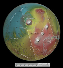
This colour-coded image shows the location and topography of a slice of Mars imaged to mark a milestone for ESA’s Mars Express: its 25 000th orbit around the Red Planet.

The area outlined by the diagonal rectangular box indicates the area imaged by Mars Express on 19 October 2023. The globe view is based on a digital terrain model of the region, from which the topography of the landscape can be derived. Lower parts of the surface are shown in blues and purples, while higher altitude regions show up in whites and reds, as indicated on the scale at the bottom. The ground resolution is <450 m/pixel and the image is centred at about 2°N/248°E.

Read more

Credits: NASA/JPL/USGS/MOLA; FU Berlin

Perspective view of Mars’s Tharsis volcanoes by europeanspaceagency

© europeanspaceagency, all rights reserved.

Perspective view of Mars’s Tharsis volcanoes

This oblique perspective view shows a slice of Mars imaged to mark a milestone for ESA’s Mars Express: its 25 000th orbit around the Red Planet.

It was generated from a digital terrain model and the nadir (downward-pointing) and colour channels of Mars Express’s High Resolution Stereo Camera. The vertical scale is exaggerated by a factor of approximately three, making the volcanoes look three times higher than they are in real life.

Three of Mars’s famously colossal volcanoes are shown creeping away over the planet’s sand-coloured horizon: from left to right, Arsia, Pavonis and Ascraeus Mons. The mound of Mars’s largest volcano, Olympus Mons, can be spied just at the top of the frame, while the fractured terrain of Noctis Labyrinthus, Mars’s ‘labyrinth of night’, can be seen in the foreground.

Read more

[Image description: This image shows a tan-coloured portion of Mars, with the curvature of the planet visible to the top right the frame. Four of Mars’s volcanoes can be seen in relief against the dark background, shown as darker mounds stretching away from the viewer.]

Credits: ESA/DLR/FU Berlin, CC BY-SA 3.0 IGO

New Mars Express image celebrates 25 000 orbits by europeanspaceagency

© europeanspaceagency, all rights reserved.

New Mars Express image celebrates 25 000 orbits

This image from ESA’s Mars Express shows a slice of Mars imaged to mark a milestone for ESA’s Mars Express: its 25 000th orbit around the Red Planet. The stunning view shows volcanoes, valleys, craters, clouds, and even a flying visit from Mars's largest moon, Phobos.

Be sure to zoom in to explore the landscape in detail!

This image comprises data gathered by Mars Express’s High Resolution Stereo Camera (HRSC) on 19 October 2023 during orbit 25 000. It was created using data from the nadir channel, the field of view aligned perpendicular to the surface of Mars, and the colour channels of the HRSC. The ground resolution is <450 m/pixel and the image is centred at about 2°N/248°E.

Read more

[Image description: This image shows a large, tan-coloured slice of Mars, with the curvature of the planet visible at the top and bottom of the frame. Cutting diagonally right to left across the centre of the planet like a belt are three darker raised patches (volcanoes). Many other features are visible across the frame, including scarred terrain, clouds, and the moon Phobos, which can be seen as a dark, irregular blob to the lower left.]

Credits: ESA/DLR/FU Berlin, CC BY-SA 3.0 IGO

Martian volcanoes in 3D by europeanspaceagency

© europeanspaceagency, all rights reserved.

Martian volcanoes in 3D

This stereoscopic image shows in 3D a slice of Mars that has been imaged to mark a milestone for ESA’s Mars Express: its 25 000th orbit around the Red Planet. It was generated from data captured by the High Resolution Stereo Camera (HRSC) on ESA’s Mars Express orbiter on 19 October 2023. The anaglyph offers a three-dimensional view when viewed using red-green or red-blue glasses.

Read more

Credits: ESA/DLR/FU Berlin, CC BY-SA 3.0 IGO

Mars - Kasei Valles, Valles Marineris, cloudy Ascreus and Pavonis Mons - Hope Mission Orbit 377 by Andrea Luck

Available under a Creative Commons by license

Mars - Kasei Valles, Valles Marineris, cloudy Ascreus and Pavonis Mons - Hope Mission Orbit 377

Download full size image here 5600X2800: www.flickr.com/photos/192271236@N03/53400614053/sizes/o/
See Licence below.

Credit: UAESA/MBRSC/HopeMarsMission/EXI/AndreaLuck

-----------------------------
Orbit:377 - Spacecraft altitude: 21893 km
Timetag 2023-05-23 00:33
Filters: f635+f546+f437 (f320 used to slightly enhance the orographic cloud over Ascraeus Mons)
Raw Data from: sdc.emiratesmarsmission.ae/
emm_exi_l2a_20230523T003307_0377_xos4_f635_r_v06-08
emm_exi_l2a_20230523T003318_0377_xos4_f546_r_v06-08
emm_exi_l2a_20230523T003338_0377_xos4_f437_r_v06-08

----------------------------------

Credit: UAESA/MBRSC/HopeMarsMission/EXI/AndreaLuck

Feel free to share, giving the appropriate credit and providing a link to the original image or tweet creativecommons.org/licenses/by/3.0/

Ascraeus Mons Flank (THEMIS_IOTD_20231115a) by ASUMarsSpaceFlight

© ASUMarsSpaceFlight, all rights reserved.

Ascraeus Mons Flank (THEMIS_IOTD_20231115a)

This VIS image shows a cross section of the eastern flank of Ascraeus Mons. Ascreaus Mons is the northernmost volcano of the three large Tharsis volcanoes. In order from north to south the volcanoes are Ascreaus Mons, Pavonis Mons and Arsia Mons. All three volcanoes form a line located along a tectonic bulge caused by extensional forces in the region. Along this trend there are increased tectonic features, collapse features, and additional lava flows that arose from the flanks of the volcanoes rather than just the summit. Like the other large volcanoes in the region, Ascraeus Mons is a shield volcano. Shield volcanoes are formed by lava flows originating near or at the summit, building up layers upon layers of lava. In shield volcanoes summit calderas are typically formed where the surface collapses into the void formed by an emptied magma chamber. Ascraeus Mons is the largest of the three volcanoes with a summit of 18km (11 miles) and a width of 460 km (286 miles). For comparison Mauna Kea - the tallest volcano on Earth - is 10 km tall (6.2 miles).

This martian scene spans 18 x 266 kilometers (11 x165 miles). To see where on Mars this area lies, and to download high-resolution versions of the image go to themis.asu.edu/zoom-20231115a

See the Red Planet Report at redplanet.asu.edu for updates on Mars research and exploration. For more about Mars geology, check out the Mars-ePedia: marsed.asu.edu/marsepedia

For the latest THEMIS Mars images as received by mission scientists, see themis.asu.edu/livefrommars. To learn more about the THEMIS camera and its Mars images, see themis.asu.edu

This image is in the public domain and may be republished free of charge. If used, please credit it as NASA/JPL-Caltech/Arizona State University.

Valles Marineris and Tharsis by jccwrt

Available under a Creative Commons by-sa license

Valles Marineris and Tharsis

Mars' Tharsis region and Valles Marineris imaged by Mars Express HRSC. This image, taken shortly after the northern hemisphere's summer solstice, captures the planet's Aphelion Cloud Belt near peak density. The cloud belt forms when the planet is furthest from the Sun, when lower atmospheric temperatures cause the condensation temperature for water ice crystals to fall to altitudes with more water vapor. The aphelion cloud belt is generally thickest over the high terrain of the Tharis volcanic region.

Olympus Mons is visible at far left, near the horizon. A small windstorm is present near its summit, lifting large dust clouds. A large orographic cloud is visible on the western slopes of Ascraeus Mons (top left/center). Pavonis Mons (left center) and the northern flanks of Arsia Mons are visible in a line just below it.

The large canyon system of Valles Marineris dominates the left side of the image. This gigantic canyon system formed due to the immense weight of the large shield volcanoes to its west. The weight of these volcanoes pushes down on the planet's interior, causing the landscape to swell and buckle in the region of Valles Marineris.

This image was taken during Mars Express' 24,725th orbit of Mars, on August 1, 2023.

Image Credit: ESA / DLR / FU Berlin / A. Cowart, CC BY-SA 3.0 IGO

Ascraeus Mons (THEMIS_IOTD_20230809a) by ASUMarsSpaceFlight

© ASUMarsSpaceFlight, all rights reserved.

Ascraeus Mons (THEMIS_IOTD_20230809a)

This VIS image shows part of the summit of Ascraeus Mons. Ascraeus Mons is the northernmost and tallest of the three large aligned Tharsis volcanoes. Calderas are found at the tops of volcanoes and are the source region for magma that rises from an underground lava source to erupt at the surface. Volcanoes are formed by repeated flows from the central caldera. The final eruptions can pool within the summit caldera, leaving a flat surface as they cool. Calderas are also a location of collapse, creating rings of tectonic faults that form the caldera rim. Ascraeus Mons has several caldera features at its summit. Ascraeus Mons is 18 km (11 miles) tall, for comparison Mauna Kea - the tallest volcano on Earth - is 10 km tall (6.2 miles, measured from the base below sea level).

This martian scene spans 17 x 258 kilometers (11 x 160 miles). To see where on Mars this area lies, and to download high-resolution versions of the image go to themis.asu.edu/zoom-20230809a

See the Red Planet Report at redplanet.asu.edu for updates on Mars research and exploration. For more about Mars geology, check out the Mars-ePedia: marsed.asu.edu/marsepedia

For the latest THEMIS Mars images as received by mission scientists, see themis.asu.edu/livefrommars. To learn more about the THEMIS camera and its Mars images, see themis.asu.edu

This image is in the public domain and may be republished free of charge. If used, please credit it as NASA/JPL-Caltech/Arizona State University.

Phobos over Ascraeus Mons - NASA 's Viking 2 1977 by Andrea Luck

Available under a Creative Commons by license

Phobos over Ascraeus Mons - NASA 's Viking 2 1977

Download full size image: www.flickr.com/photos/192271236@N03/53066242230/sizes/o/ (License Below)

Credit:
NASA/JPL/AndreaLuck

Colourised image created using data processed from pds-imaging.jpl.nasa.gov/

Mission: VIKING ORBITER2 - EXTENDED_MISSION
Distance from Phobos: 8000 km
Orbit: 304
Instrument: VISUAL_IMAGING_SUBSYSTEM_CAMERA_B
Time: 1977-06-23 T 11:17:04
Product ID: f304b88 (planetarydata.jpl.nasa.gov/img/data/viking/viking_orbiter...)

Notes from NASA: Viking 2 Orbiter image of Phobos orbiting over Ascraeus Mons on Mars. Phobos is about 8000 km below the spacecraft and 22 km across. Ascraeus Mons is 13,000 km away and about 300 km at its base, centered at 11 N, 104 W. North is at 11:30, and Phobos is moving from left to right relative to the surface.

Credit:
NASA/JPL/AndreaLuck

Feel free to share, giving the appropriate credit and providing a link to the original image or tweet: creativecommons.org/licenses/by/3.0/