The Flickr Ohioriver Image Generatr

About

This page simply reformats the Flickr public Atom feed for purposes of finding inspiration through random exploration. These images are not being copied or stored in any way by this website, nor are any links to them or any metadata about them. All images are © their owners unless otherwise specified.

This site is a busybee project and is supported by the generosity of viewers like you.

Coal tow on the Ohio by jimross90

© jimross90, all rights reserved.

Coal tow on the Ohio

I thought I would try out my 2007-era four-thirds (pre-micro four thirds) camera today instead of my 2014-era full frame. I had to work with it a little in post. This is the Crounse Corp. boat Jean Akin southbound with 15 heavily loaded coal barges, I assume for a power plant in the Cincinnati area or below. Coal tows aren't nearly as numerous around here as they were 15 years ago. That's the Chesapeake, Ohio, area of Lawrence County as seen from Huntington, West Virginia (America's Best Community winner).

Changing of the Guard by OhioDOT

© OhioDOT, all rights reserved.

Changing of the Guard

Ohio Department of Transportation crews add the new Ohio Governor John Kasich and Lt. Gov. Mary Taylor's names to the welcome sign above the William Harsha Bridge near Aberdeen, Ohio Friday, January 14, 2011. The bridge spans the Ohio River between Aberdeen, Ohio and Maysville, Kentucky. (AP Photo/The Ledger Independent, Terry Prather.)

94I067 - Looking northwest from Shawnee Park, Louisville, Kentucky, Ohio River mile 610, September 30, 1994 by Bill Alden

Available under a Creative Commons by-sa license

94I067 - Looking northwest from Shawnee Park, Louisville, Kentucky, Ohio River mile 610, September 30, 1994

94I067 - Looking northwest from Shawnee Park, Louisville, Kentucky, Ohio River mile 610, September 30, 1994

Looking northwest from Shawnee Park
Louisville, Kentucky
Ohio River mile 610
September 30, 1994

The paved surface of the Riverwalk is partly visible through the foliage at lower left.

Gallagher Station, a coal-fired power plant, can be seen across the river. Opened in 1958, it was shut down in 2021 and the boiler house was imploded in 2024.

Scanned from a 6x9 cm Kodak Kodachrome 64 (PKR 6033) transparency

94J001 - LG&E Cane Run generating station, Louisville Kentucky, Ohio River mile 617, October 3 1994 by Bill Alden

Available under a Creative Commons by-sa license

94J001 - LG&E Cane Run generating station, Louisville Kentucky, Ohio River mile 617, October 3 1994

94J001 - LG&E Cane Run generating station, Louisville Kentucky, Ohio River mile 617, October 3 1994

Looking southeast from Floyd County, Indiana, toward Jefferson County, Kentucky
Ohio River mile 617
October 3, 1994

Across the river in Louisville, Kentucky, is LG&E's Cane Run generating station. It began generating electricity from coal in 1954. By 1969, the plant had 6 units with a total generating capacity of 943 megawatts (MW). Three coal-fired units had been retired by 1987 (though their stacks remained) and in 2015, the other three were shut down. This coincided with the placing into service of Unit 7, a 691 MW natural gas combined-cycle (NGCC) generating unit. The coal-burning structure was demolished in 2019.

Towboat "Wayne McBride" is upbound with an empty hopper barge.

Twin screw towboat "Wayne McBride" (doc. # 554585, length 60 feet, breadth 22 feet, Caterpillar D353TA diesels (?), 850 hp).
Built in 1974 by Serodino, Inc., Guild, Tennessee.
Originally named "Delta Dawn", owned by Flowers Transportation, Greenville, Mississippi.
In 1979, sold to Arkansas River Co., Greenville.
In 1981, renamed "Martha Amee" .
In 1991, sold to Five M Transportation Corp., Louisville, Kentucky, and renamed "Wayne McBride".
Still operating in 2025.

Scanned from a 6x9 cm Kodak Kodachrome 64 (PKR 6033) transparency

M/V Jean Akin by jimross90

© jimross90, all rights reserved.

M/V Jean Akin

I thought I would try something different in editing this image. I thought of the glamor glow portraits of about 30 years ago and figured why not try to emulate them with an inanimate object and see what I got. I don't know if you would call this a glamor (or glamour) shot, but I enjoyed the process of figuring it out. Isn't that one reason we enjoy this pastime and post here?

94J017 - Putting sailboats in water before Fleur de Lis Regatta, Louisville, Kentucky, Ohio River mile 603, October 8, 1994 by Bill Alden

Available under a Creative Commons by-sa license

94J017 - Putting sailboats in water before Fleur de Lis Regatta, Louisville, Kentucky, Ohio River mile 603, October 8, 1994

Putting sailboats in water before Fleur de Lis Regatta, Louisville, Kentucky, Ohio River mile 603, October 8, 1994

Looking ENE from riverfront near foot of Floyd Street
Louisville, Kentucky
Ohio River mile 603
October 8, 1994
File # 94J017

This is near the former site of the Klempner Bros. scrap yard, between the Port of Louisville Terminal and the Martin-Marietta sand yard. At the time, the three sites had been mostly cleared before development as Waterfront Park. The Kennedy and Big Four Bridges are in the distance.

The Fleur de Lis Regatta was an annual series of sailboat races held near downtown Louisville. It was a fundraiser for the cancer support group Gilda's Club, and it was held at least through 2018, but I'm not sure about the years after that.

A Little Giant crane (looks like a model 7.5MT) provided by the Metropolitan Sewer District is lowering an E Scow into the river. The blue-green boat at left and the yellow boat in the foreground are Thistles, a centerboard sloop class commonly used for racing. The white boats on the right are Highlanders, also a centerboard sloop class.

Scanned from a 6x9 cm Kodak Kodachrome 64 (PKR 6033) transparency

Steel City Tail Lights by rladuca3

© rladuca3, all rights reserved.

Steel City Tail Lights

The long exposure light trails add some warmth to the blue hour in downtown Pittsburgh - as seen from Mt. Washington.

97H073 - Raising the sunken "Belle of Louisville" at 4th Street wharf, Louisville, Kentucky, August 31, 1997 by Bill Alden

Available under a Creative Commons by-sa license

97H073 - Raising the sunken "Belle of Louisville" at 4th Street wharf, Louisville, Kentucky, August 31, 1997

Looking ENE from middle level of Belvedere connector near foot of 4th Street
Louisville, Kentucky
Ohio River mile 604
August 31, 1997

On August 24, 1997, the excursion steamer "Belle of Louisville" partially sank at her moorings. The proximate cause of the sinking was flooding of the hull via a city water line left connected to a fitting that led into the boat's hull, causing water to fill the engine room at a rate of 60 gallons per minute. A former seasonal crew member, Brennan James Callan, was later convicted of sabotage, though he always maintained his innocence.

The bow sank onto the mud ledge near the wharf while the stern, weighed down by all that water in the engine room, slid off into deeper water. After determining that the hull was intact, the boat was pumped out. To provide stability, the Corps of Engineers derrick boat "Brown" (left) supported the stern during the pump-out. I count at least 9 portable pumps, including two on a barge and one not in operation.

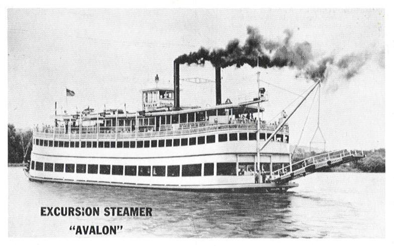
Sternwheel steamboat "Belle of Louisville" (Length 192 feet - Width 41 feet - capacity 998 passengers).
Built 1914 by James Rees & Sons Co., Pittsburgh, Pennsylvania, and rebuilt in 1968 by Jeffboat, Jeffersonville, Indiana.
Engines 16's - 6 1/2 foot stroke.
Three return flue boilers (built by Nooter Corp., St. Louis, Missouri, and placed in 1968), each 28 feet long by 56 inches outside diameter, with 13 six inch flues. Burns fuel oil.
Originally named "Idlewild" and owned by the West Memphis Packet Co., the boat operated at times as a packet, excursion boat and ferry.
In 1928, the boat was sold to New St. Louis and Calhoun Packet Corp., Hardin, Illinois.
In 1947, the boat was sold to J. Herod Gorsage, Peoria, Illinois, and in 1948 she was renamed "Avalon".
In 1950, the boat was sold to Steamer Avalon, Inc., Cincinnati, Ohio.
In 1962, the boat was sold at auction for $34,000 to Jefferson County, Kentucky, under the leadership of County Judge Marlow Cook, and renamed "Belle of Louisville".
As of 2024, the boat is still running public and private cruises from the wharf.

One of the Belle's captains, Mike Fitzgerald, can be seen in a maroon shirt near the edge of the wharf. He worked his way up from deckhand, and in 2024 celebrated his 50th year with the Belle.

The derrick boat "Brown" was put into service in 1976 and can lift 135 tons. Basically a non-self-propelled deck barge with a rotating crane, the "Brown" is anchored in position with through-deck steel shafts called "spuds" (at left, with tops painted yellow) that are lowered to the river bottom. It was named after Edgar W. Brown, the Corps derrick boat operator who died in an accident at Kentucky River Lock 3.
[From "The Falls City Engineers" (revised edition) by Leland R. Johnson, p. 172]

As an aside, the Corps of Engineers has a derrick boat which can lift 350 tons, the "Henry M. Shreve". And here are some photos of older derrick boats.

Scanned from a 6x9 cm Kodak E100SW transparency

97H075 - Derrick boat "Brown" assisting in raising the sunken 'Belle of Louisville' at 4th Street wharf, Louisville, Kentucky, August 31, 1997 by Bill Alden

Available under a Creative Commons by-sa license

97H075 - Derrick boat "Brown" assisting in raising the sunken 'Belle of Louisville' at 4th Street wharf, Louisville, Kentucky, August 31, 1997

97H075 - Derrick boat "Brown" assisting in raising of sunken "Belle of Louisville" at 4th Street wharf, Louisville, Kentucky, August 31, 1997

Looking NNE from stairway near foot of 4th Street
Louisville, Kentucky
Ohio River mile 604
August 31, 1997

On August 24, 1997, the excursion steamer "Belle of Louisville" partially sank at her moorings. The proximate cause of the sinking was flooding of the hull via a city water line left connected to a fitting that led into the boat's hull, causing water to fill the engine room at a rate of 60 gallons per minute. A former seasonal crew member, Brennan James Callan, was later convicted of sabotage, though he always maintained his innocence.

The bow sank onto the mud ledge near the wharf while the stern, weighed down by all that water in the engine room, slid off into deeper water. After determining that the hull was intact, the boat was pumped out. To provide stability, the Corps of Engineers derrick boat "Brown" (left) supported the stern during the pump-out. I count at least 9 portable pumps, including two on a barge and one not in operation.

The derrick boat "Brown" was put into service in 1976 and can lift 135 tons. Basically a non-self-propelled deck barge with a rotating crane, the "Brown" is anchored in position with through-deck steel shafts called "spuds" (at left, with tops painted yellow) that are lowered to the river bottom. It was named after Edgar W. Brown, the Corps derrick boat operator who died in an accident at Kentucky River Lock 3.
[From "The Falls City Engineers" (revised edition) by Leland R. Johnson, p. 172]

As an aside, the Corps of Engineers has a derrick boat which can lift 350 tons, the "Henry M. Shreve". And here are some photos of older derrick boats.

At left is the Louisville Falls Fountain, a floating fountain which operated from 1988 to 1998. It was said to be inspired by the Jet d'Eau, a fountain in Geneva, Switzerland, but was never quite that spectacular.

Scanned from a 6x9 cm Kodak E100SW transparency

M/V Jean Akin at the Gallipolis Locks and Dam by jimross90

© jimross90, all rights reserved.

M/V Jean Akin at the Gallipolis Locks and Dam

I know. The formal name is the Robert C. Byrd Locks and Dam, but I grew up with it as the Gallipolis Locks and Dam, and that's what it is to me.

Ohio River and Old Chesapeake & Ohio Railway Tracks (Maysville, Kentucky) by courthouselover

© courthouselover, all rights reserved.

Ohio River and Old Chesapeake & Ohio Railway Tracks (Maysville, Kentucky)

Aberdeen, in Brown County, Ohio, is visible in the background.

Maysville, Kentucky is located on the Ohio River, in the northeast of the commonwealth, roughly between Columbus, Ohio and Lexington. It serves as the seat of Mason County, and is one of the most charming, well-preserved communities I have encountered in the Bluegrass State.

97J034 - Rowers on Ohio River (mile 603) near foot of Towhead Island, Louisville, Kentucky, October 19, 1997 by Bill Alden

Available under a Creative Commons by-sa license

97J034 - Rowers on Ohio River (mile 603) near foot of Towhead Island, Louisville, Kentucky, October 19, 1997

Looking west from Kentucky bank of Ohio River near foot of Towhead Island (at right)
Louisville, Kentucky
Ohio River mile 603
October 19, 1997
File # 97J034

This is the former site of Riverway Louisville Terminal, close to the current (2025) location of the Brown-Forman Amphitheater.

Five women are rowing in a Dirigo rowing shell (possibly model ZXE).

In the distance are four bridges: Big Four (originally a railroad bridge, now a pedestrian bridge), Kennedy (Interstate 65), Clark (US Hwy 31) and L&I (railroad bridge, formerly Pennsylvania Railroad, then Conrail).

Scanned from a 6x9 cm Kodak E100SW transparency

97J035 - Rowers on Ohio River (mile 603) near foot of Towhead Island, Louisville, Kentucky, October 19, 1997 by Bill Alden

Available under a Creative Commons by-sa license

97J035 - Rowers on Ohio River (mile 603) near foot of Towhead Island, Louisville, Kentucky, October 19, 1997

Looking northwest from Kentucky bank of Ohio River near foot of Towhead Island
Louisville, Kentucky
Ohio River mile 603
October 19, 1997
File # 97J035

This is the former site of Riverway Louisville Terminal, close to the current (2025) location of the Brown-Forman Amphitheater.

Five women are rowing a Dirigo rowing shell (possibly model ZXE) in the channel between Towhead Island and the Kentucky bank.

Big Four Bridge (originally a railroad bridge, now a pedestrian bridge) at left.

Scanned from a 6x9 cm Kodak E100SW transparency

M/V Marathon by jimross90

© jimross90, all rights reserved.

M/V Marathon

M/V Scarlett Rose Furlong by jimross90

© jimross90, all rights reserved.

M/V Scarlett Rose Furlong

As seen from beautiful downtown Ashland, Kentucky, traffic circle capital of the Bluegrass State

Ruins of Cairo by sniggie

Ruins of Cairo

Sakura over Sodaikawa by sniggie

Sakura over Sodaikawa

Translation: Cherry blossoms over the Ohio (Ohio is from the Iroquois word for Grand River, “O-Y-O." It also means good morning in Japanese, which language I tried to make my title sound like, as these are cherry blossoms that Japan is famous for. 😉)

Kentucky's shore is on the far side of the river.

PXL_20250410_133612274.RAW-01.MP.COVER by Mill Creek Alliance

© Mill Creek Alliance, all rights reserved.

PXL_20250410_133612274.RAW-01.MP.COVER

PXL_20250409_174229310.RAW-01.COVER by Mill Creek Alliance

© Mill Creek Alliance, all rights reserved.

PXL_20250409_174229310.RAW-01.COVER