The Flickr Rickguidice Image Generatr

About

This page simply reformats the Flickr public Atom feed for purposes of finding inspiration through random exploration. These images are not being copied or stored in any way by this website, nor are any links to them or any metadata about them. All images are © their owners unless otherwise specified.

This site is a busybee project and is supported by the generosity of viewers like you.

Space Colony Concept Agriculture by NASA on The Commons

Space Colony Concept Agriculture

Agricultural modules in a cutaway view (multiple toroids). This concept from a summer study done in 1977 depicts a closed loop life support system for long duration space settlements or space industrialization. Artwork by Rick Guidice.

NASA Media Usage Guidelines

Credit: NASA/Ames Research Center/Rick Guidice
Image Number: AC78-0330-4
Date: April 18, 1978

Cylinder Interior by NASA on The Commons

Cylinder Interior

Interior view of a torus wheel space colony concept looking out through large windows. Artwork by Rick Guidice.

NASA Media Usage Guidelines

Credit: NASA/Ames Research Center/Rick Guidice
Image Number: AC75-1086
Date: May 27, 1975

Bernal Interior by NASA on The Commons

Bernal Interior

This illustration created by artist Rick Guidice shows the interior of a Bernal Sphere space colony concept. Inside the sphere gravity is strongest along the equator. As one moves toward the center gravity lessens and one could fly easily. Sunlight enters as shown by the large fuzzy ring. The central tube connects to other sections of the colony.

NASA Media Usage Guidelines

Credit: NASA/Ames Research Center/Rick Guidice
Image Number: AC76-0628
Date: April 1, 1976

Exterior View of the Bernal Sphere Space Colony Concept by NASA on The Commons

Exterior View of the Bernal Sphere Space Colony Concept

The residential area for this space colony concept is in the central sphere. Farming regions are in the 'tires.' Mirrors reflect sunlight into the habitat and farms. The large flat panels radiate away extra heat into space, and panels of solar cells provide electricity. Factories and docks for spaceships are at either end of the long central tube. Painted by artist Rick Guidice.

NASA Media Usage Guidelines

Credit: NASA/Ames Research Center/Rick Guidice
Image Number: AC76-0965
Date: June 11, 1976

piovns_v_c_o_TPMBK (AC79-9084) by Mike Acs

© Mike Acs, all rights reserved.

piovns_v_c_o_TPMBK (AC79-9084)

An artist’s concept of a rift valley on Venus. “The lowest spot on the surface of Venus is on the floor of these valleys, Diana Chasma.”

Although no signature is visible, I’m sure it’s one of many works by Rick Guidice during the 1970s for Ames Research Center (ARC), as is this one, and the Jet Propulsion Laboratory (JPL).

The image and above quoted extract, accompanied by a ‘computer-generated’ three-dimensional plot and another rift valley concept are on pages 124 & 125 of “NASA SP-461: PIONEER VENUS”, at:

ntrs.nasa.gov/api/citations/19830022069/downloads/1983002...

From the estate of Eric Burgess.

piovns_v_c_o_TPMBK (A78-9125) by Mike Acs

© Mike Acs, all rights reserved.

piovns_v_c_o_TPMBK (A78-9125)

“Artist’s concept of Aphrodite Terra, largest highland region on Venus.”

The largest continent-sized highland region on Venus is Aphrodite. It is comparable in size to the northern half of Africa, and consists of two mountainous areas separated by a somewhat lower region. Situated almost on Venus’s equator, Aphrodite Terra runs almost directly east and west for 9600 km.
Unlike Ishtar [Terra], a relatively level plateau carrying high mountains, the Aphrodite highland rises to various heights above the mean planet surface. The western mountainous area towers 8000 m above the surrounding terrain, 9000 m above Venus mean surface. The eastern mountains of Aphrodite rise 3300 m above the surrounding terrain, 4300 m above the mean surface. Like Ishtar, the mountain terrain appears to be quite rough. Because Aphrodite does not appear to contain uplifted plateaus or volcanic mountains, Aphrodite may be older and more degraded than Ishtar.”

The above are both the caption & associated writeup for the image, from the July 1980, Vol. 11, No. 7 issue of “NASA Activities”, which is surprisingly and most pleasantly available here:

www.parrygamepreserve.com/images/media/magazines/nasa_act...

And here:

www.parrygamepreserve.com/images/media/magazines/nasa_act...
Both above credit: “Parry Game Preserve” website, and with a WHOLE LOT MORE – outstanding!

One of many works by Rick Guidice during the 1970s for Ames Research Center (ARC), as is this one, and Jet Propulsion Laboratory (JPL).

The image (with a superimposed outline of the continental United States), accompanied by a ‘computer-generated’ three-dimensional plot and cross section are on page 121 of “NASA SP-461: PIONEER VENUS”, at:

ntrs.nasa.gov/api/citations/19830022069/downloads/1983002...

The photo is from the estate of Eric Burgess & was possibly featured in the December 1980 issue of "Star & Sky" magazine, possibly as part of an article titled "Venus Unveiled".

piovns_v_c_o_TPMBK (AC78-9145) by Mike Acs

© Mike Acs, all rights reserved.

piovns_v_c_o_TPMBK (AC78-9145)

“A possible pattern for the meridional circulation in the atmosphere of Venus”

Above per the caption associated with a diagrammatical representation (Figure 6-37) of the image, from “PIONEERING VENUS: A Planet Unveiled” co-written by Richard O. Fimmel, Lawrence Colin & Eric Burgess, from whose estate it originates.

With the following pertinent/accompanying extract:

“Dynamical Processes

The cloud system is embedded in the general circulation of the atmosphere at altitudes of greatest wind velocity and vertical wind shear. Atmospheric motions consist mainly of a zonal circulation. The atmosphere moves from east to west with velocities increasing from a few meters per second at the surface to sometimes as high as 150m/sec (490 ft/sec) at cloud tops. The average cloud top velocity corresponds roughly to the four-day circulation.

Also, the data suggest a major, although much slower, north-south circulation at several meters per second. It occurs at altitudes corresponding to the cloud region. There seems to be atmospheric movement from equator to poles at altitudes corresponding to the tops of the clouds. The movement subsides at the poles. Return flow toward the equator is at altitudes that match the lower part of the main cloud region. The atmosphere rises again near the equatorial region. Such north-south cellular motions are called Hadley cells. The combination of east-west and north-south motions produces vortices in the polar region. These affect the haze layer and produce an apparent cloud top depression in the vortices. They also might be the reason for the “pileup” of high latitude hazes and the even higher latitude “cold ring” observed by the Orbiter’s instruments. Figure 6-37 is a schematic drawing of the suggested circulation pattern.”

At a Tamil website, with a very similar image, the cells - from the planet’s surface outward - are labeled as follows: SURFACE CIRCULATION CELL (brown), MID-ALTITUDE CELLS (lavender?), SUB-CLOUD CELL (blue), CIRCULATION DRIVER CELL (CLOUD LAYER) (light tan) & tenuous-looking STRATOSPHERE CELL. The other labeled features such as SURFACE, POLAR VORTICES & CLOUD TOPS are self-evident.

Accompanied by the following, taken from whatever original source document was cited:

“Venus’ atmospheric circulations: Solar energy is absorbed in the cloud layer, which covers the planet. The upper layer carries heat from the equator to the poles where it sinks, returns to the equator, heats, and rises again. The driver cell engages other cells above and below it, like a train of counter-rotating gears, mixing the planet’s atmosphere thoroughly.”

Respectively, the above are from:

www.scribd.com/document/46302082/Pioneering-Venus-a-Plane...
Credit: SCRIBD website

old.thinnai.com/?p=40309112
Credit: திண்ணை: தமிழின் முதல் இணைய வாரப்பத்திரிக்கை (Tinnai: Tamil's first web weekly) website

Artwork by Rick Guidice.

pio10/11_v_bw_o_n (ARC photo no. A 73-4843.1) by Mike Acs

© Mike Acs, all rights reserved.

pio10/11_v_bw_o_n (ARC photo no. A 73-4843.1)

Based on the year, I’m sure this work was commissioned by the Ames Research Center (ARC) to coincide with the Pioneer 10 & 11 missions to Jupiter. Originally, I thought it depicted the four Galilean moons, thinking the dark one to be a shadow…of one of them…oops, wrong. So it’s "Galilean 4" + 1.

Unfortunately, no artist’s signature is present, although ARC’s ‘go-to’ artist of this time & subject seems to have been Rick Guidice…so maybe him?

Compare/contrast:

images.nasa.gov/details-ARC-1972-AC72-1350

fut_v_c_o_TPMBK (AC76-0628) by Mike Acs

© Mike Acs, all rights reserved.

fut_v_c_o_TPMBK (AC76-0628)

ROTFL(&C)MAO:

“ARTIST: Rick Guidice Space Colonization; inside the sphere gravity is strongest along the equator. as on moves toward the center gravity lessens and one could fly easily. Sunlight enters as shown by the large fuzzy ring. The central tube connects to other sections of the colony.”

Above & image at…yep, you guessed it:

images.nasa.gov/details-AC76-0628

The only useful information provided is the identy of the artist.

And, since everybody and their brother has taken it upon themselves to describe/‘caption’ this image over the decades, the bits & pieces are disjointed, some incoherent (read above), with discrepancies, contradictions & just useless pablum.

Thankfully, the National Space Society offers the following:

“Towards the end of this century, possibly by the early 1990s, the workforce of a space manufacturing complex may well enjoy living quarters of the sort pictured here. By then, it is thought, manufacturing in outer space can be a substantial enterprise. Some major industries which are foreseen at this time are zero-gravity manufacturing and the provision of clean, inexpensive power. Power would be generated at satellite solar power stations and transmitted by microwave to Earth.

The habitat design shown here, made visual by NASA artist R. Guidice, is known as a “Bernal Sphere.” Houses, lawns, trees, people, and all – a community of some 10,000 people – rest upon the interior surface of a large sphere, nearly a mile in circumference. The entire sphere rotates at about 1.9 RPM, producing centrifugal force as a substitute for gravity. At the equator, this simulated “gravity” is of about Earth-normal intensity. Away from the equator, it tapers off, diminishing gradually to zero at the poles. This offers the inhabitants some unusual recreational opportunities: human-powered flight, for example, and zero-gravity sports.

Near the equator of the rotating habitat wanders a small river whose shores are made of lunar sand. Natural sunshine is brought in through external mirrors. Inhabitants can have the “weather” they prefer, without worrying about its effect upon the crops: agriculture is conducted in neighboring edifices, outside the spherical portion of the habitat.

For the short distances within the space habitat, automobiles would be unnecessary, and transport would be on foot or bicycle. A climb from the equator past the small villages on the hillsides, to the rotation axis where gravity would be zero, would take about twenty minutes. A corridor at the axis would permit floating in zero-gravity out to external structures, such as the agricultural areas, the observatories, the docking ports, and contiguously located industries. Part of the workforce would take various means of conveyance to more remote worksites, such as a satellite solar power station, some kilometers off in space.”

At:

space.nss.org/bernal-sphere-space-settlement-detail/

Along with:

space.nss.org/bernal-sphere-space-settlement/

Ishtar Terra/cont. USA ('Intelligent Design' blog/website download) by Mike Acs

© Mike Acs, all rights reserved.

Ishtar Terra/cont. USA ('Intelligent Design' blog/website download)

“Venus Highland—Artist’s concept of Ishtar Terra, loftiest and most dramatic continent-sized highland region on Venus, is based on radar mapping accomplished by the Pioneer Venus orbiter. Western part of Ishtar is mostly a smooth plateau, but the eastern region, at right, changes to a huge uplifted, broken region topped by the highest point yet found on Venus, a mountain massif called Maxwell Montes. This version of Rick Guidice’s concept features the outline of the continental United States superimposed to illustrate the relative size of Ishtar.”

The above is an extract & paraphrasing from the July 1980, Vol. 11, No. 7 issue of “NASA Activities”. This, along with the “non-USA” image were both featured on the cover of the issue.

This is the ONLY version (of less than a handful) that I came across, that was of reasonable resolution & in color, since the NASA photo history…whoever, whatever it was, couldn’t even find the ball, let alone drop it.

At:

larryemarshall.files.wordpress.com/2016/02/ishtar.jpg
Credit: Larry E. Marshall/”Intelligent Design” website/WordPress

fut_v_c_o_TPMBK (AC76-0965) by Mike Acs

© Mike Acs, all rights reserved.

fut_v_c_o_TPMBK (AC76-0965)

“Bernal Sphere Exterior

Built to accommodate some 10,000 people, this “Bernal Sphere” space colony would serve as the residential area of a space manufacturing complex. The inhabitants would conduct a variety of manufacturing activities in space: some located within the structure shown here, others in nearby reaches of space. For example, a major industry is expected to be the provision of clean, inexpensive power, generated at satellite solar power stations and transmitted by microwave to Earth.

In the picture, “home” is to be found within the spherical portion. There is more than meets the eye: the visible surface is an outer shell which shields the habitat from cosmic rays and solar flares. This shell is accumulated from the slag of industrial processes, which are carried out using lunar surface material as input. Inside the shell, an inner sphere, almost a mile in circumference, rotates to provide “gravity” comparable to that of the Earth. Residents’ homes stand upon the inside surface of the inner sphere.

The structure at the two ends of the axial portion are docking areas and the sites of zero-gravity manufacturing. The flat, paddle-like fixtures radiate away the waste heat of the habitat into the cold of outer space. Nearer to the sphere, the stacked rings are agricultural areas, helping provide for the needs of the workforce. Here agricultural crops, far less sensitive to radiation than humans would be, are grown in the intense sunlight of space. The simulated “gravity” in these areas is about 0.7 that of the Earth; the atmospheres are optimized for the growth of various crops.

The slightly curved plates, arranged in a circle surrounding the sphere, are the second stage in a series of mirrors which bring sunlight into the habitat at controlled hours. At a locus outside the picture, the mirrors of the first stage govern the “day-night” cycle. The second-stage mirrors pass the light at a desired angle to the ring-shaped mirrors capping the sphere. From these last, finally, the sunlight is directed into the interior of the sphere.

In the 1976 NASA Study on Space Manufacturing, habitats of this type, very efficient in their use of materials for shielding, are thought of as next steps beyond more utilitarian structures. An earlier stage of development would involve shielded versions of the agricultural areas shown here.

It is thought that habitats of this type will be technically feasible towards the end of this century, possibly by the early 1990s. One calculation has indicated that with the level of industrial activity which is contemplated for space by that time, and with the means of transportation by then available, construction of such a habitat could proceed in about two months. Accumulation of the shield would take place over the ensuing two years.”

Above, with the image at/from:

space.nss.org/bernal-sphere-space-settlement-detail/

There’s also this:

space.nss.org/bernal-sphere-space-settlement/

And this:

space.nss.org/colonies-in-space-chapter-8-the-highest-home/
All above credit: National Space Society (NSS) website

Further, the image, displayed at varying orientations, along with a host of other disjointed descriptions can be found all over the place.

Not bad:

en.wikipedia.org/wiki/The_High_Frontier:_Human_Colonies_i...
Credit: Wikipedia

And:

www.sciencefriday.com/articles/this-70s-artist-painted-ou...
Credit: Science Friday website

Finally, referred to as “Island Two”, although, at another site, “Island One”. Like Ted Nugent said “It’s a free-for-all”:

www.spacesafetymagazine.com/space-exploration/space-colon...
Credit Space Safety Magazine website

One of many gorgeous works Rick Guidice created for the 10-week long summer study sponsored by the Ames Research Center & Stanford University.

pio10_v_c_o_n (72-H-140, 73-HC-110, AC72-1354 eq) by Mike Acs

© Mike Acs, all rights reserved.

pio10_v_c_o_n (72-H-140, 73-HC-110, AC72-1354 eq)

“Artist’s concept of Pioneer over Jupiter’s Red Spot.

Man will reach out beyond Mars to take the first close look at the planet Jupiter on the mission of the unmanned Pioneer F spacecraft, to be launched by the National Aeronautics and Space Administration from Cape Kennedy, Fla., between Feb. and March 1972. The trip to Jupiter will last less than two years, for most launch dates, with most arrival times before Dec. 31, 1973. Jupiter is a spectacular planet. It appears to have its own internal energy source and is so massive that it is almost a small star. It may have the necessary ingredients to produce life. Its volume is 1,000 times that of Earth, and it has more than twice the mass of all the other planets combined. Striped in glowing yellow-orange and blue-gray, it floats in like a bright-colored rubber ball. It has a huge red “eye” in its southern hemisphere and spins more than twice as fast as Earth. Pioneer’s 13 scientific experiments are expected to provide new knowledge about Jupiter and many aspects of the outer solar system and our galaxy. It will return the first close-up images of Jupiter, and will made the first measurements of Jupiter’s twilight side, never seen from Earth.”

From the estate of Eric Burgess, and possibly featured as figure 3-3(a) in an unidentified publication by him.

Although disappointingly, wrongly, yet as expected, acknowledged nowhere within the following document, I’m quite certain that this beautiful work is by Rick Guidice. As the title/header image for chapter 4, along with the title/header artist’s concepts within the publication confirmed to be by Mr. Guidice, a reasonable extrapolation. Besides, it was probably contractually agreed to by Mr. Guidice & NASA.

In color:

images.nasa.gov/details-ARC-1972-AC72-1354

Along with others. Always exceptional:

e05.code.blog/category/nasa-un-crewed-programs/pioneer/
Credit: numbers station blog

piovns_v_c_o_TPMBK (A78-9126) by Mike Acs

© Mike Acs, all rights reserved.

piovns_v_c_o_TPMBK (A78-9126)

“Venus Highland—Artist’s concept of Ishtar Terra, loftiest and most dramatic continent-sized highland region on Venus, is based on radar mapping accomplished by the Pioneer Venus orbiter. Western part of Ishtar is mostly a smooth plateau, but the eastern region, at right, changes to a huge uplifted, broken region topped by the highest point yet found on Venus, a mountain massif called Maxwell Montes.”

The above is an extract from the July 1980, Vol. 11, No. 7 issue of “NASA Activities”. The image & the image with an outline of the continental United States superimposed over Ishtar Terra, were both featured on the cover of the issue.

In lieu of finding the image - SURPISE - my initial attempt at a description:

Artist’s concept of Ishtar Terra, the northern highland/continental mass of two such regions on Venus. Roughly the size of the contiguous United States, points on Ishtar rise to about 11 kilometers above the planet’s mean level.

One of many works by Rick Guidice during the 1970s for Ames Research Center (ARC), as is this one, and Jet Propulsion Laboratory (JPL).

The above is based on information as of ca. 1983, paraphrased from “NASA SP-461: PIONEER VENUS”, to include the version of the image with the overlaid outline of the contiguous U.S.A.

At:

ntrs.nasa.gov/api/citations/19830022069/downloads/1983002...

From the estate of Eric Burgess & possibly featured in the December 1980 issue of "Star & Sky" magazine, possibly as part of an article titled "Venus Unveiled".

pio11_v_c_o_TPMBK (AC74-9041) by Mike Acs

© Mike Acs, all rights reserved.

pio11_v_c_o_TPMBK (AC74-9041)

“PIONEER 11 COURSE TOWARD INTERSTELLAR SPACE”

Probably the most beautiful, creative & striking version 😉 out of hundreds, if not thousands, depicting Pioneer 11’s historic mission and path to infinity…and beyond.

It being an Ames Research Center image, from 1974, of a Pioneer-Jupiter spacecraft, with dynamic ‘space’, I gotta go with Rick Guidice.

Despite the rendering, I'm pretty sure the spacecraft didn't fly between Saturn and its rings. Note also the outline of an unpainted deflection arrow at/behind "SPACE".

“INTERSTELLER”, UGH.

piovns_v_c_o_TPMBK (AC78-9132) by Mike Acs

© Mike Acs, all rights reserved.

piovns_v_c_o_TPMBK (AC78-9132)

“Imaginary view of Maxwell Montes as seen across the plains of Venus.”

“…On the eastern side of Ishtar the huge Maxwell Montes thrust their peaks high into the Venusian sky. Maxwell was discovered by Earth-based radar. On it is a great circular feature which may be a caldera about 100 km across and 1 km deep which is offset toward the east flank of the mountain some 2 km below the summit. No bright flows radiate from this caldera. The implication is that erosion has smoothed any lava flows. If so, the volcano much be much older than those in Beta Regio. Much of the slopes of Maxwell are, however, bright in the radar images, indicating that they are covered with rocks that scatter the radar signal, probably because the slopes of the mountains are covered with debris. Polarization data indicate that these slopes are rougher than the very rough floor of the fresh lunar-impact crater Tycho, which is the roughest area of the Moon.”

The above is from the photo caption and applicable text from “NASA SP-461: PIONEER VENUS”, appropriately enough & commensurate with the provenance of the photo…co-authored by Mr. Eric Burgess. Pleasantly surprisingly, at the NTRS:

ntrs.nasa.gov/api/citations/19830022069/downloads/1983002...

Impeccable provenance in the form of Eric Burgess. Capped off by it being the work of Rick Guidice.

bion_v_c_o_TPMBK (ca. 1973-79) by Mike Acs

© Mike Acs, all rights reserved.

bion_v_c_o_TPMBK (ca. 1973-79)

"The Bion satellites (Russian: Бион), also named Biocosmos, is a series of Soviet (later Russian) biosatellites focused on space medicine. They are part of the Kosmos satellites.

Bion Space Program

Bion precursor flights and Bion flights:

The Soviet biosatellite program began in 1966 with Kosmos 110, and resumed in 1973 with Kosmos 605. Cooperation in space ventures between the Soviet Union and the United States was initiated in 1971, with the signing of the United States and Soviet Union in Science and Applications Agreement (which included an agreement on space research cooperation). The Soviet Union first offered to fly U.S. experiments on a Kosmos biosatellite in 1974, only a few years after the termination (in 1969) of the U.S. biosatellite program. The offer was realized in 1975 when the first joint U.S./Soviet research were carried out on the Kosmos 782 mission.
The Bion spacecraft were based on the Zenit spacecraft and launches began in 1973 with primary emphasis on the problems of radiation effects on human beings. Launches in the program included Kosmos 110, 605, 690, 782, plus Nauka modules flown on Zenit-2M reconnaissance satellites. 90 kg (200 lb) of equipment could be contained in the external Nauka module.
The Soviet/Russian Bion program provided U.S. investigators a platform for launching Fundamental Space Biology and biomedical experiments into space. The Bion program, which began in 1966, included a series of missions that flew biological experiments using primates, rodents, insects, cells, and plants on a biosatellite in near-earth orbit. NASA became involved in the program in 1975 and participated in 9 of the 11 Bion missions. NASA ended its participation in the program with the Bion No. 11 mission launched in December 1996. The collaboration resulted in the flight of more than 100 U.S. experiments, one-half of all U.S. life sciences flight experiments accomplished with non-human subjects.
The missions ranged from five days (Bion 6) (Kosmos 1514) to around 22 days (Bion 1 and Kosmos 110).

Bion-M:

In 2005, the Bion program was resumed with three new satellites of the modified Bion-M type – the first flight was launched on 19 April 2013 from Baikonur Cosmodrome, Kazakhstan. The first satellite of the new series Bion-M1 featured an aquarium by the German Aerospace Center (DLR) and carried 45 mice, 18 Mongolian gerbils, 15 geckos, snails, fish and micro-organisms into orbit for 30 days before re-entry and recovery. All the gerbils died due to a hardware failure, but condition of the rest of the experiments, including all geckos, was satisfactory. Half the mice died as was predicted.

Bion-M2 is scheduled to launch in 2023 on a Soyuz 2.1a rocket to an altitude of 800 km. The orbiter will carry 75 mice and studies will focus on how they are affected at the molecular level by space radiation."

The above from/at. Although I’m sure the links won’t be clickable:

en.wikipedia.org/wiki/Bion_(satellite)
www.wikiwand.com/en/Bion_(satellite)
Credit: Wikipedia/Wikiwand websites

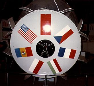
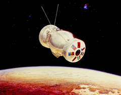
A surprise to me, it's by the hand of Rick Guidice.
It’s beautiful of course, the colors, the ‘texture’, the clouds, their shadows, sun glint…exquisite.

You know, if festooned with another 15 - 20 ungainly antennas, 30+ meters of additional external wiring and several more spherical fuel tanks, one can almost picture Gagarin inside or Leonov egressing. 😉 In fact, if you slap on a couple of solar arrays, you've got a semi-Soyuz.
Note the DaVinci “Vitruvian Man” at the center of what I think is the battery module, which was also incorporated into the Skylab II mission emblem.
Curiously, note also the respective orientation of the flags of the U.S. & U.S.S.R. They are - appropriately enough - the opposite of each other. That is, the Stars & Stripes has the 'fly end' toward the center, whereas the hammer & sickle has the 'hoist' end toward the center. Furthermore, the flags of Romania & Poland are oriented as the U.S. flag is, while the flags of Czechoslovakia, France & Hungary/Magyarország are as that of the U.S.S.R.
If this was truly a "joint/cooperative” effort, all of the flags should’ve been oriented the same, no?
There's probably a 15-page MOU/MOA that took three days to arrive at regarding this trivial point.

At the following, where the depiction is identified as Bion no. 11. However, with all due respect to the proprietor of the excellent website, based on what (admittedly little) I know of the period of Mr. Guidice’s remarkable space/astronomy artwork, along with the photo paper’s watermark, I believe the print to be from the 1970s.

www.astronautix.com/b/bion.html
Credit: Astronautix website

Additionally, based on the identification of one of the images at the above, at:
www.astronautix.com/graphics/c/cosmo782.jpg
...and a mission date which falls within my guesstimated date range, this may be a depiction of Bion 3/Kosmos 782. This would actually make sense, it being the first Bion mission that the United States participated in. That would seem to merit being depicted by the likes of Mr. Guidice. 😉

See also:

en.m.wikipedia.org/wiki/Kosmos_782
Also credit: Wikipedia

Furthermore, at the following link. BTW, Mr. Zak is incredibly knowledgeable regarding Soviet/Russian space…pretty much everything. Really quite impressive. I recommend taking a good look at his stuff, especially on Twitter. You won’t be disappointed:

www.russianspaceweb.com/bion.html
Credit: Anatoly Zak/RussianSpaceWeb.com website

Last, but not least. Unfortunately, with no amplifying information and at very low resolution:

rickguidice.com/nasaart/nasaarti.html

Specifically:

rickguidice.com/images/241_Untitled-51_edited-2.jpg
Credit: the website of Rick Guidice

vns_v_c_o_TPMBK (AC77-0475-4) by Mike Acs

© Mike Acs, all rights reserved.

vns_v_c_o_TPMBK (AC77-0475-4)

A possible Venusian landscape, as depicted in 1977 by the eminently talented Rick Guidice, for NASA’s Ames Research Center.

archive.org/details/AILS_AC77-0475-7
Credit: Internet Archive website

That, or it's the Land of Gorch. In fact, I think I see Scred in one of the crevasses:

muppet.fandom.com/wiki/The_Land_of_Gorch?file=Landofgorch...
Credit: Muppet Wiki website

superradnow.wordpress.com/2011/06/14/the-forgotten-muppet...
Credit: SuperRadNow website

pio11_v_c_o_TPMBK (AC74-9006.4) by Mike Acs

© Mike Acs, all rights reserved.

pio11_v_c_o_TPMBK (AC74-9006.4)

“Artist’s conception showing Pioneer 11 as it will look passing Saturn in September 1979. Pioneer’s passage of the ringed planet will be the first flight to Saturn, which is 887 million miles from the Sun. Tentative plans call for Pioneer 11 to fly through the space between the inner ring and the planet’s cloud tops, and then to come close to Saturn’s large moon, Titan. Titan’s environment is considered favorable for living organisms. After passing Saturn and photographing and measuring the planet, its rings and moons, the spacecraft will leave the solar system altogether. Pioneer 11 flew past Jupiter in December 1974.”

See also:

www.nasa.gov/sites/default/files/thumbnails/image/ac74-90...

www.nasa.gov/image-feature/45-years-ago-pioneer-11-launch...

An interesting inverted variant of this serves as the cover art of the NASA/Ames Research Center publication, "PIONEER SATURN ENCOUNTER":

www.gutenberg.org/files/55695/55695-h/55695-h.htm
Credit: Project Gutenberg website
Which looks to be well worth exploring further...FREE eBooks...outstanding!

Interesting background information on Mr. Guidice:

www.sciencefriday.com/articles/this-70s-artist-painted-ou...

www.numulosgatos.org/exhibitions-2/2015/9/17/rick-guidice...

fut_v_c_o_TPMBK (S-75-32860) by Mike Acs

© Mike Acs, all rights reserved.

fut_v_c_o_TPMBK (S-75-32860)

Interesting background and peripheral info, especially regarding the artist - Rick Guidice - at:

www.sciencefriday.com/articles/this-70s-artist-painted-ou...

www.numulosgatos.org/exhibitions-2/2015/9/17/rick-guidice...

Also, interesting:

space.nss.org/settlement/MikeCombs/SCTHF.html
Credit: National Space Society website

biet thu sec by timeshousedesign

© timeshousedesign, all rights reserved.

biet thu sec

Various Angles and Vantages from Clos de la Tech Winery