
“Photograph from National Aeronautics and Space Administration’s Surveyor I spacecraft. Spherical mosaic of narrow-angle photographs of the Lunar scene at low sun illumination. Craters and fine detail of the surface enhanced by the low oblique lighting. Center of mosaic is southwest of spacecraft. Tilt of horizon is due to non-verticle mounting of the camera. The picture was received at the National Aeronautics and Space Administration’s Jet Propulsion Laboratory.”
Yes, “verticle”…I’ll leave it alone.
It’s a cool image & historic, but I don’t like it being cropped at the horizon. Actually, I don’t like any of the cropping they did. Why?
The mosaic (for all intents & purposes), labeled as ‘Surveyor 1-20’ by the Lunar and Planetary Institute (LPI), were taken/assembled in order to provide an identical view to ‘Surveyor 1-19’, but at a different illumination angle. It/they were also then combined with ‘Surveyor 1-21’ in order to provide a complete 360-degree view of the landing site.
All per/at the wonderful LPI website:
www.lpi.usra.edu/resources/mapcatalog/Surveyor/press_rele...
Specifically:
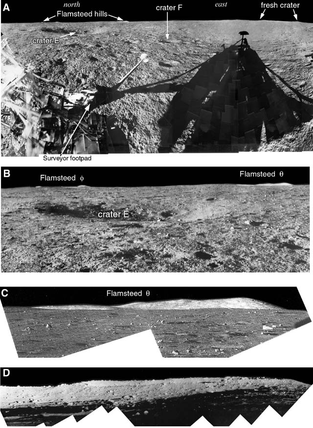
“Surveyor 1-19
Spherical mosaic of narrow-angle photographs of the lunar scene taken by Surveyor I on June 12, 1966, two days before nightfall on the moon. Each photo chip is two inches square and represents a six-degree field of view as seen by Surveyor’s TV camera. The pictures are arranged on the concave surface of a three-foot hemisphere to form the panorama. The sun is shining from the west (right). Tilt of the horizon is due to off-vertical mounting of the camera on the spaceframe. The scene portrayed is the same as that shown 24 hours later with the sun at a lower angle in picture #20.”
Image at:
www.lpi.usra.edu/resources/mapcatalog/Surveyor/press_rele...
“Surveyor 1-20
Mosaic of narrow-angle pictures of moon taken by Surveyor I’s television camera forms a panoramic view of lunar terrain stretching approximately 130 degrees across horizon. Each photo chip is two inches square and represents a six-degree field of view as seen by the camera. The pictures are mounted in overlapping fashion against the concave surface of a three-foot hemisphere. When completed, the hemispheres in pictures #20 and #21 will form a complete 360-degree view from Surveyor. The narrow-angle survey was made June 13, about 24 hours before sundown on the site pictures.”
Image at:
www.lpi.usra.edu/resources/mapcatalog/Surveyor/press_rele...
“Surveyor 1-21
Mosaic of narrow-angle pictures of moon taken by Surveyor I’s television camera forms a panoramic view of lunar terrain stretching approximately 115 degrees across the horizon. Dramatic elongated shadow of the spacecraft was created by the low sun sinking on the horizon behind Surveyor. Each photo chip is two inches square and represents a six-degree field of view as seen by the camera. The pictures are mounted on the concave surface of a three-foot hemisphere. When completed, the hemispheres in pictures #21 and #20 will form a complete 360-degree view from Surveyor. Parts of the spacecraft identifiable at left are (from top) one of the antenna booms, helium tank, nitrogen tank (cantilevered on braces) the auxiliary battery. The survey was made June 13, about 24 hours before sundown on the site pictured.”
Image at:
www.lpi.usra.edu/resources/mapcatalog/Surveyor/press_rele...
Also:
www.smithsonianmag.com/air-space-magazine/surveyor-1-amer...
Credit: Smithsonian Magazine online website
Last, but NOT least:
“EUGENE M. SHOEMAKER, Chief, Astrogeology Branch, U.S. Geological Survey, commented on the scene:
"It shows the intricately cratered surface of the Oceanus Procellarum. It is a gently undulating surface pockmarked with craters, ranging from a few centimeters to several hundred meters in diameter, and littered with blocks and fragments, ranging from less than a millimeter to more than a meter across. The craters and the fragmental debris were probably formed by bombardment of the lunar surface by meteoroids and by pieces of the Moon itself, hurled through space from larger craters.
"The pitted appearance of the lunar surface [which one observer has likened to that of a World War I battlefield] is enhanced by the presence of long shadows, extending away from the spacecraft's foot and the more prominent blocks, due to the low angle of incidence of the rays of the evening Sun."
Above at/from:
history.nasa.gov/SP-168/section2a.htm


")
")
")
")
")
")
")
")
")
")