

This page simply reformats the Flickr public Atom feed for purposes of finding inspiration through random exploration. These images are not being copied or stored in any way by this website, nor are any links to them or any metadata about them. All images are © their owners unless otherwise specified.
This site is a busybee project and is supported by the generosity of viewers like you.


")

“General geography of the Descartes region. The ruggedness of the lunar highlands is shown very well in this sketch of the region by artist Jerry Elmore. Note the flat bottoms of the large craters. We are looking due east. The trajectory of the descending LM is shown as the heavy location of area of Figure 6 is indicated by the light dashed line.”
Yet another pathetic & minimal ‘effort’, incompetently copied from “ON THE MOON WITH APOLLO 16: A Guidebook to the Descartes Region”, NASA EP-95. Read/re-read the last sentence. Even the simple act of copying…correctly, apparently a bridge too far.
The caption from it, as originally written:
“FIGURE 7.-General geography of the Descartes region. The ruggedness of the lunar highlands is shown very well in this sketch of the region by artist Jerry Elmore. Note the flat bottoms of the large craters. We are looking due east. The trajectory of the descending LM is shown as the heavy dashed line. Location of area of Figure 6 is indicated by the light dashed line.”
Above at/from:
www.hq.nasa.gov/alsj/a16/A16OTM01-14.pdf
Credit: ALSJ website
Also:
history.nasa.gov/EP-95/p9.htm
Despite obviously being a ‘working’ copy of the image, the photograph has retained its high gloss. The taped area to the upper left, which may have been to affix something, as there’s no damage, will remain. It’s removal would also take with it the minor crater visible.
When presented ICW with Mr. Elmore’s other landing site depictions, as in the above cited publication, the image provides excellent context WRT the Descartes landing site. Oddly/Pleasantly surprisingly, to even include attribution to Mr. Elmore!
")
“APOLLO 16 LANDING SITE-----An artist’s concept illustrating an eastward view of the Apollo 16 Descartes landing site. The white overlay indicates the scheduled traverses by the Apollo 16 astronauts in the Lunar Roving Vehicle. The Roman numerals are the EVAs: and the Arabic numbers are the station stops along the traverses. The Descartes landing area is generally west of the Sea of Nectar and southwest of the Sea of Tranquility. The LRV traverses extend northward to the Smokey Mountains near Station 14 and southward to Stone Mountain near Station 4. Astronauts John W. Young, commander, and Charles M. Duke Jr., lunar module pilot, will descend in the Lunar Module to the lunar surface to explore the Descartes landing site, while Astronaut Thomas K. Mattingly II, command module pilot, will remain with the Command and Service Modules in lunar orbit.”
Let’s face it, out of the Apollo “J” missions, the Apollo 16 Descartes Highlands landing site was by far the least visually interesting. Other than ‘House Rock’ & North Ray crater, it was pretty dull.
Did that contribute to this being basically nonexistent online? Although it is buried & languishing at the following decremented long-defunct website. Although grateful, I’m appalled that, pathetically, THIS is still the only place I find low-resolution images, with their ID numbers. In fact, multiple nice images ‘exist’ within this untended gravesite. Sad:
science.ksc.nasa.gov/mirrors/images/images/pao/AS16/10075...
science.ksc.nasa.gov/mirrors/images/images/pao/AS16/10075...
Although I assume there was one, I don’t even remember the Tang poster for this landing site…or that I even had it…whereas I clearly recall having Apollo 15 & 17. That’s pretty bad…I feel sorta guilty.
Very nice artwork by NASA artist Jerry L. Elmore, responsible for the Apollo 15 & 17 depictions as well.

“Apollo 14 Landing Site
With the engineering successes of Apollo 11 and 12, the next mission was dedicated to scientific exploration of the Moon – destination the Fra Mauro highlands. The main science goal for Al Shepard and Ed Mitchell was acquiring samples from a range of depths as far down as 30 or 40 m – without a drill! Nature provided the astronauts with a cross section of the local geology in the form of ejecta from Cone crater (340 m diameter). The outer edges of the ejecta are composed of material from near the surface where the asteroid (or comet) impacted, while the ejecta at the rim of the crater comes from deepest regions within the crater. All the key science goals were met with two extra-vehicular activities lasting just under 10 hours total.”
I didn’t see anything like this on this photo hosting ‘service’, hence this post. Which, along with a WHOLE LOT MORE, at:
lroc.sese.asu.edu/exhibits/A%20New%20Moon%20Rises/6
Credit: NASA/GSFC/LROC, School of Earth and Space Exploration, Arizona State University website
")
RCA artist’s concept, possibly depicting Apollo 16 Commander John Young tending to the Ground Commanded Television Assembly (GCTA), manufactured by RCA.
The identification as Apollo 16 is based on a much more knowledgeable source’s identification as such. The terrain in the background should be a clue, but it really isn’t. I originally thought it was Apollo 15, with an undersized St. George crater on the slope of Mons Hadley Delta. Frankly, the Apollo 16 landing site, other than having relief, is not particularly distinguishable, so I suppose maybe that’s Stone Mountain in the background. But, I don’t recall a conspicuous single crater like that on it. The background could also loosely pass for Taurus-Littrow I guess. That ‘mountain’ being one of the Massifs, but again, that lone crater throws that off. Realistically, I bet the artist wasn’t even trying to represent whatever landing site it is. It’s the television camera and its related equipment that mattered in this depiction.
Other than that ambiguity, it’s really a very nice work by Rudy Baum, apparently/possibly an RCA artist.
")
“Traverse from Station 4 to Station 5.
www.hq.nasa.gov/alsj/a16/AS16-110-17978HR.jpg
As Charlie mentions in the dialog, they are headed in the general direction of the LM. In a detail,
www.hq.nasa.gov/alsj/a16/a16det17978LM_HouseRock.jpg
Don McMillan has labeled both the LM and House Rock.”
All above at/credit: ALSJ website/Don McMillan
That's really impressive. How in the world did Mr. McMillan deduce the location of either, let alone both? The LM I can sort of understand, due to the brightened appearance of the regolith by the Lunar Module Descent Engine (LMDE) exhaust. I suppose based on that and the relative positions of the surface features, craters, etc., ‘House Rock’ could then be determined? But it’s a mere dot. Again, very impressive.
A photo that really captures the exponential increase in exploration capability provided by the LRV. And what a serious hike it would’ve been back to the LM in case of a “breakdown”.
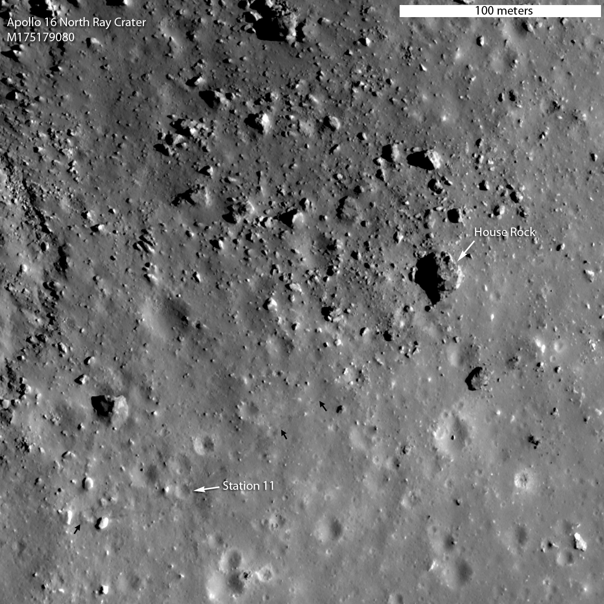
Finally, a fantastic LROC photograph of the landing site, providing an excellent labeled perspective of what we’re looking at. House Rock is located on the southeast rim of North Ray crater...Station 11 basically. Pretty awesome:
lroc.sese.asu.edu/news/uploads/a16_lroc_traversemap.png
lroc.sese.asu.edu/news/uploads/M175179080LR_thumb.png
Both above credit: LROC, School of Earth and Space Exploration, Arizona State University website
")
“A computerized rendering illustrating the field of view for the Astronauts on the approach to the landing site for the NASA Apollo 17 Lunar mission.”
Cutting edge late-1972 visual graphics technology on display! The crater shadows do however look like they're by hand. 😉
Actually, the depiction, especially that of the elevated regions, is remarkably detailed and accurate when compared to mission photographs.
")
“This is a relief map of the landing site made by the U. S. Army Photographic [Topographic] Command. The landing site is here several kilometers east of Hadley Rille. The Apennine Mountains are off the relief map further off to the east. There five objectives at the landing site: The first and primary objective is to sample the mountain front. At this particular place the Apennine Mountains for a slight bow to the west so that the mountains which are further off to the east here come around and we are able to sample south of the landing site some of the Apennine front material. That is the primary objective of the mission. The secondary objective of the mission is to study the rille itself. The sinuous, meandering rilles on the moon are an enigma at this time. The third objective is to look at the mare itself. We are now quite a bit further north than any of the other mares we visited. This is in particular a very dark mare. It may be one of the youngest mares that we can visit on the moon. The fourth objective is the north complex. The most probable interpretation at this time is that this is a volcanic complex. There are other interpretations possible. The sampling will take place at several points in the north complex. And the final objective is this cluster of craters southeast of the landing site, and these are believed to be secondaries from the large craters, Autolycus and Arostyllus [Aristillus], which are much further to the northwest within the Mare Imbrium itself.”
With the above task list, it’s a testament to David Scott’s professionalism, commitment and dedication to becoming an astute student & practitioner of geology/geological observation. Not that I expect anyone to do it, but if you watch - listen actually - to his commentary & observations while on moon, it’ll blow you away, especially if you’re a Geologist. I’m sure Jack Schmitt was proud. And not to slight Irwin, but Scott’s efforts were singularly exceptional.
This photograph is really cool, in that it’s actually a photograph of an actual relief map, (with EVA traverses superimposed). A pretty good one at that. Then again, it had to be, after the POS the Army crapped out for Apollo 13/14. I’m surprised NASA gave them another/continuing opportunity.
One of the physical relief maps is seen here:
dygtyjqp7pi0m.cloudfront.net/i/29546/25729474_2.jpg?v=8D3...
Credit: RR Auction/icollector.com
It sold for something like a bajillion dollars, +/- a couple of billion.
To me, this landing site was by far the most spectacular visually as well.
")
“Apollo 17 visibility study altitude 503 sea 17° flt. Crew trw.”
The view looking out the Lunar Module window of Cdr. Eugene Cernan, from an altitude of 503 feet, as displayed in the Lunar Module Simulator, at the KSC Landing and Ascent Facility. The grid-like markings comprise the Landing Point Designator (LPD).
I believe the extended relief feature to be South Massif. I wish I could identify the larger crater on the right. Too small to be Camelot I think, especially at 500'? Could Cernan even see Camelot at this point? Steno? Powell?
Excellent LM descent/ascent reading:
www.hq.nasa.gov/alsj/nasa58040.pdf
Credit: ALSJ website
")
Just thought it was kinda neat; one being the quadrangle in which the landing was going to occur (prior to site selection), and the other, after the fact, of the localized site within it.
pubs.er.usgs.gov/publication/i510
pubs.usgs.gov/imap/0510/plate-1.pdf
pubs.er.usgs.gov/publication/i618
pubs.usgs.gov/imap/0618/plate-1.pdf
Geologic maps do nothing for me, but these sort of have some historic significance, hence posting. But, shaded relief maps are another story...they’re definitely neat!


pictionid74771087 - catalog- s70-50764 image from sandiegoairandspacemuseum.org pleasa tag. image may be subject to copyright laws. - - title- dennis r. jenkins collection 1970 space history photo - - filenames70-50764.jpg
")
Wonderful & surely rare commemorative raised relief map of Tranquility Base, as produced by the United States Army Topographic Command (TOPOCOM), ca. 1969/70.
Erroneously, an Apollo 12 photograph of Pete Conrad on the moon is with the U.S. flag is featured. Really...how do you mess that up?! The photo of Aldrin facing/saluting Old Glory was plastered everywhere!
I believe the larger crater to the far right - it’s rim immediately to the right of the “e” - to be Little West Crater.
TOPOCOM even took a stab at where the U.S. flag was planted. And actually, as a military organization, it’s pretty much expected. Speaking of U.S. flags on the moon...absolutely awesome:
www.hq.nasa.gov/alsj/ApolloFlags-Condition.html
Credit: not surprisingly, the ALSJ
")
Wonderful & surely rare commemorative raised relief map of Tranquility Base, as produced by the United States Army Topographic Command (TOPOCOM), ca. 1969/70.
TOPOCOM even took a stab at where the U.S. flag was planted. And actually, as a military organization, it’s pretty much expected. Speaking of U.S. flags on the moon...awesome:
www.hq.nasa.gov/alsj/ApolloFlags-Condition.html
Credit: not surprisingly, the ALSJ
I don’t understand the two “camera stations” at/on the LM. One, sure, initially as part of the MESA. But the other? Or is it just referring to photography out the two LM windows?
Compare/contrast. So cool. Again, pretty damned good job:
mobile.twitter.com/contactlight69/status/868510755745918978
Credit: “CONTACT LIGHT”/Twitter
")
Wonderful & surely rare commemorative raised relief map of Tranquility Base, as produced by the United States Army Topographic Command (TOPOCOM), ca. 1969/70.
I believe the larger crater to the far right - it’s rim immediately to the right of the “e” - to be Little West Crater.
TOPOCOM even took a stab at where the U.S. flag was planted. And actually, as a military organization, it’s pretty much expected. Speaking of U.S. flags on the moon...absolutely awesome:
www.hq.nasa.gov/alsj/ApolloFlags-Condition.html
Credit: not surprisingly, the ALSJ
Compare/contrast. So cool. Again, pretty damned good job:
mobile.twitter.com/contactlight69/status/868510755745918978
Credit: “CONTACT LIGHT”/Twitter
")
Wonderful & surely rare commemorative raised relief map of Tranquility Base, as produced by the United States Army Topographic Command (TOPOCOM), ca. 1969/70.
Erroneously, an Apollo 12 photograph of Pete Conrad on the moon is with the U.S. flag is featured. Really...how do you mess that up?! The photo of Aldrin facing/saluting Old Glory was plastered everywhere!
I believe the larger crater to the far right - it’s rim immediately to the right of the “e” - to be Little West Crater.
TOPOCOM even took a stab at where the U.S. flag was planted. As a military organization, it’s pretty much expected.

“Apollo Landing Site 3
This sample plastic relief map depicts a portion of the precise lunar topographic model prepared for the National Aeronautics and Space Administration. This model is an integral part of a Lunar Module Simulator. The simulator provides crew training and orientation for Apollo Astronauts for scheduled lunar landings and is installed at the John F. Kennedy Space Center, Cape Kennedy Florida. The “lunar surface was prepared by the U.S. Army Topographic Command from Orbiter IV and V photography provided by NASA. The completed model contains over 500,000 craters, measures 22 feet by 14 feet, and weighs approximately 600 pounds.”